Precision Soil Testing vs.Traditional Soil Testing – is the decision to move toward precision testing simply a function of field size & equipment capability? Or is it more complex than that? What does implementing a precision ag fertility program mean & is it worth it? What data points will you need to ensure your variable rate applications are suitable? RtC Agronomists have the same questions and work with our customers to provide answers. In 2023, Rosetree Agronomists worked with several of our customers to look at the fertilizer input costs using traditional flat rate applications vs. VR applications developed using grid sampling or zone sampling. Our blog answers the question, what is the difference between traditional soil testing and precision soil testing?
Precision agriculture soil testing and traditional soil testing are two distinct approaches to assessing nutrient needs on your farm. These methods have evolved, each with its own set of advantages and limitations. Understanding the differences between these approaches is essential to making informed decisions about optimizing crop yield and managing input costs.
Traditional soil testing relies on a generalized approach to field management. Agronomists collect 10-15 soil cores from different parts of a field, mix them, and send a composite sample to a lab for analysis. Next, the lab will provide nutrient content and pH levels, which are used to make uniform manure & fertilizer recommendations for the entire field.

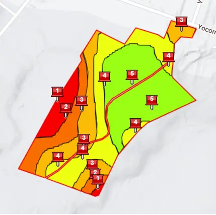
Precision soil testing is a technology-driven approach that aims to provide manure & fertilizer recommendations at the sub-field level. Managing at the sub-field level can increase crop yield and resource (fertilizer, seed, etc.) efficiency. Precision ag soil testing involves using GIS Platforms (Geographic Information Systems), like the FieldAlytics system used by Rosetree Consulting, to create detailed sampling maps within a field. Grid sampling and zone sampling are the two most common soil testing layers created by a GIS platform. These layers then guide the collection of soil samples from specific locations using GPS + a GIS application loaded on a phone or tablet.
The key differences between precision ag soil testing and traditional soil testing are:
Spatial Variability:
- Precision Ag: Precision ag soil testing considers the spatial variability of soil properties within a field. Different areas with varying soil types, textures, and nutrient levels are identified and managed separately.
- Traditional: Traditional soil testing provides an average nutrient content for the entire field, ignoring potential variations across the landscape.
Data Collection:
- Precision Ag: Precision Ag relies on GPS-guided harvesting equipment, active remote sensing & passive remote sensors to gather precise data points from specific locations. These data layers generate detailed maps and insights.
- Traditional: Traditional soil testing involves collecting randomized samples manually from different parts of the field and then creating a composite sample. This method does not capture fine-scale variations.
Decision Making:
- Precision Ag: With detailed maps highlighting yield & nutrient variability, farmers can make targeted decisions about fertilization and planting, optimizing resource allocation. Precision Ag is all about decision-making!
- Traditional: Recommendations from traditional soil testing provide “whole field” fertilization rates that may work great in small field sizes or fields with low variability but may underperform in larger fields or fields with moderate to high variability.
Efficiency and Cost:
- Precision Ag: While precision ag soil testing can be more time-consuming and expensive due to technology use, it can lead to cost savings in the long run by optimizing input usage.
- Traditional: Traditional testing is often more cost-effective upfront, but it might lead to suboptimal resource allocation and potentially higher costs over time.
Yield and Environmental Impact:
- Precision Ag: Layered zone creation based on multiple data layers allows for sub-field management of yield & inputs. The result is a potential increase in crop yields, improving overall nutrient use efficiency, and reducing nutrient loss into surface & groundwater.
- Traditional: Traditional testing might result in over-fertilization in some areas and under-fertilization in others, affecting both yield and the environment.
Adaptability:
- Precision Ag: Precision Ag allows for adaptive management, as new data is incorporated to make real-time decisions during the growing season.
- Traditional: Traditional testing provides recommendations based on a single snapshot, making it less adaptable to changing conditions.

In our 2023 project, we compared the cost of a flat-rate fertilizer program with the price of a variable-rate (VR) fertilizer program developed using either grid sampling or zone sampling. It’s important to understand that each participant in the project adopts precision ag in varying ways. Some have years of yield data & are already doing VR planting scripts, while others have no history of precision ag.
The starting point for a farm looking to enter precision Ag differs from their neighbor or friend. A farm entering a precision ag fertility system with no history has limited choices – grid sample, multi-year layered NDVI, electric conductivity layer, or a modified version combining 2 or 3 options. We’ve had several dairy farm customers ask us to test their 40–60-acre blocks based on their contour strip layout in the 1990s because they still see variability from those old strips. Farms with yield data have more choices:
- They need to do the work to ensure that their yield data is “good” and that they are not using layers with obvious issues that would influence zone creation (thinking of the soybean field with visible groundhog damage on the yield map or the corn field with last year’s strip trials).
- The farm needs to think about how to perform the soil testing procedure.
- A decision must be made to determine what strategy(ies) they will use to implement a fertility plan.
Talk with your RtC Agronomist to see which precision ag soil testing process – grid or zone- suits your operation.

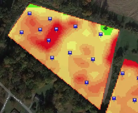
Grid Sampling: There are a number of reasons to use grid sampling. We recommend grid sampling if an operation does not have a farm/field yield history if yield variability is insignificant, or if strip trials/management practices have influenced yield within only a portion of the field. Our area’s most common grid size is 2 acres, with some plot work done on a smaller scale. Refrain from using grid sizes greater than 2.5 acres. Some farms have strip trials in fields that ultimately skew yield data. Using a standard grid sampling layer alone or combined with multi-year NDVI or contoured yield works well for these farms.
Each grid location can be moved, and additional testing locations can be added to any grid sampling job. These “modified grids” help tease out more significant trends within a field, such as the previously mentioned strip trial scenario or manure application setbacks. The setback area, where no manure is applied, should have very different fertility levels. Still, sampling using only the grid points may mute the immediate change in fertility levels at the setback line. In this situation, we can create a zone boundary within the grid sampling layer and add additional sampling points along the zone boundary.
Zone Sampling:
Where do we start with zones? This is both a rhetorical question and an actual question. Instead of focusing on the question of zone creation, let’s focus on what the zone output will look like. Will it be for VR lime, manure, or fertilizer? Will it be for VR seeding? Can it be used for both? (probably not). Does the operator want a consistent script across many farms or an individualized script for each field? Will this be one export layer (several fields on one layer), or will each be its layer? Who will be doing the applications & with what Equipment? What is the lag time for rate changes? Talk with your client to understand the needs & hurdles.
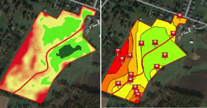
Let’s focus on developing a soil testing zone that can be used for variable-rate manure & fertilizer applications. Zones are usually created using multiple layers of data, combined or overlaid, to produce sub-field management zones. The gold standard for zone creation is multi-year yield analysis (MYYA), at least 3-5 years of clean yield data, excluding years with extreme weather. With a complete history of yield data, the following layers can be added to complete yield data to produce zones.

- NDVI – NDVI imagery from a drone or satellite can be combined with yield layers. High-quality NDVI, at the correct growth stage, can correlate strongly with yield layers. They are effective at capturing sub-field variability. In operations where windrowed forage harvesting layers are available, NDVI may pair well. There have also been some instances where the increasing width of platform heads for small grain & bean harvest mask variability occurs across the head width.
- Electric Conductivity (EC) – a Veris layer- can also be obtained through planter attachment. EC layers are great for defining soil type boundaries. They are limited as a sole source for zone development because they do not capture yield variability within the soil boundary. Be very cautious about developing VR applications based solely on EC layers.
- Soil Mapping Units & Topography Maps – these are of limited use but can be used occasionally. Never use a soil map as your base layer for sampling – they are too inaccurate. We will bring these layers into zone creation for specific reasons. Riverbottom fields often have a defining line between riverbottom alluvial soils and upslope colluvial soils. A soil map is an easy way to show that approximate boundary and avoid sampling locations on the boundary. Topography maps help understand some NDVI variations, as north-facing and south-facing slopes within the same field will have different reflective values.
- Surprisingly, Old aerial images are handy layers to bring into your zone creation process. Our current fields were often once 12 different strips, and the variability of those old strips still shows up.
If you have yield data, you have the ultimate indicator for zone creation success. Something needs to be fixed if your soil testing zones look different from your yield maps. Stop the soil testing job and discuss how to resolve the issue with your provider.
Whatever road a farm takes to make a precision fertility plan based on grids or zones, there are a few basic things to remember. Just because you’re doing fancy soil testing doesn’t mean you can forget soil testing fundamentals.
- Zone sampling – we still need a representative sample. One sampling location within a zone is not good enough. There is still variability within zones that must be managed through representative testing. You can log points within a zone or even create grids to establish repeatable locations & manage sub-zone variability. We try to have at least 8-10 sampling points in a zone.
- Grid sampling – if the predetermined sampling point looks wrong, MOVE! There are several reasons to move your grid point—rock outcroppings, depressions, gullies, old field boundaries, groundhog holes, etc.
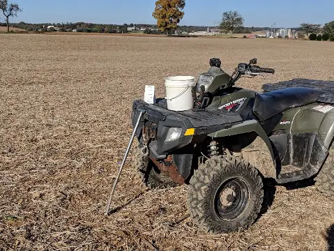
- Grid sampling – take enough cores. Don’t take one core next to each wheel of your ATV. Again, 8-10 cores should be the goal.
- Technology & Equipment – Ensure your GPS is accurate enough for the job! Some phones/tablets provide enough accuracy, while others require an additional GPS signal. BadElf GPS units easily plug into your phone, significantly increasing your location accuracy.
Precision ag soil testing and traditional soil testing represent two distinct paradigms in agricultural management. Both can be used successfully. Precision ag leverages technology to assess and manage spatial variability, enabling targeted decisions and potential resource savings. Traditional testing offers a more straightforward and cost-effective approach but might not optimize resource utilization or account for variations. As technology advances, your operation’s chances of adopting precision soil testing methods will likely increase. Talk with your RtC agronomist and trusted advisors to understand what testing methods suit you and how those soil testing events tie into VR seed scripts & VR nitrogen script goals. Also, determine how you will calculate success from your precision ag investment. Precision Ag is all about increasing your decision-making level – take the time to make a good decision before you start!
At Rosetree Consulting, we provide you with accurate and insightful soil testing services, helping you unlock the full potential of your land while promoting sustainable and environmentally responsible practices. Contact us for soil testing and agricultural services in Pennsylvania and New Jersey.

